Showing posts with label Mankato bike loop series. Show all posts

Monday, September 12, 2011

Breaking down the loops


Here's a quick recap of the four bike loops listed on the Greater Mankato Visitors Bureau's hiking/bike trail map. Hopefully my regular readers aren't "looped out" after having to suffer through four lengthy blog posts and my column in Monday's paper:

St. Clair/Eagle Lake Loop
Distance: 28.25 miles
Dominant geographical feature: Le Sueur River valley
Best place to eat along the way: Eagle's Nest, though Uptown Tavern has decent prices and free popcorn
Best known point of interest: Probably the Duke Burger at Eagle's Nest, though you might want a group of people with you if you're going to order it
Best kept secret on the route: Wildwood Park and its swinging-foot bridge. Doesn't seem like a lot of people know about that place

Sakatah/Madison Lake Loop
Distance: 14.75 miles
Dominant geographical feature: Lakes, lakes and more lakes
Best place to eat along the way: Trailblazer Bar & Grill
Best known point of interest: Madison Lake and Eagle Lake have some decent swimming areas. There's good fishing in that area too if you want to pack a fishing rod
Best kept secret on the route: Nothing really comes to mind unless you're going to continue east on the Sakatah Trail

Kasota Prairie/St. Peter Loop
Distance: 34 miles
Dominant geographical feature: Tie between the Kasota Prairie and the Minnesota River valley
Best place to eat along the way: For a quick lunch, I'd say River Rock Coffee. For a sit-down meal, I'd say Whiskey River.
Best known point of interest: The aforementioned Kasota Prairie and the Kasota Stone Quarry
Best kept secret on the route: The Amish furniture store in St. Peter is pretty cool to check out and the Linnaeus Arboretum at Gustavus Adolphus is a beautiful area to walk through if you feel like doing some hiking

Red Jacket/Rapidan/Lake Crystal/Minneopa Loop
Distance: 34 miles
Dominant geographical feature: Minneopa Falls, with strong consideration to the three river valleys and the Rapidan Dam
Best place to eat along the way: The Dam Store
Best known point of interest: Minneopa Falls
Best kept secret on the route: Justin Morneau's house if you're a Twins fan. If not, there's some pretty cool hiking trails around Mount Kato. I would say Minnemishinona Falls, but with the new bridge, it's starting to not be a secret anymore.

Thursday, August 11, 2011

Learning the Loops: Kasota Prairie/St. Peter


Note: This is Part 2 of a four-part series on the bike loops listed in the Greater Mankato Visitors Bureau's biking/hiking trails map

Distance: 34 miles, though the distance increases if you decide to explore areas of St. Peter or forget to take a key left turn (the latter of which happened to me).

Directions: I began the loop by hopping on the Minnesota River Trail at the Main Street entrance downtown and heading north. When the trail intersects with 3rd Ave, take a left and continue heading north. After about three or four miles, the road curves to the left and turns into 355th Ave. Continue on that road until you get to Kasota, where you take a right on Hill Street and a left two blocks later onto Rabbit Road.

Continue north on Rabbit Road until it ends on Highway 99. Take a left onto Highway 99 and follow it through St. Peter. Once out of St. Peter, the road turns into County Road 5. About a mile or so past the Swanson's Tennis Center/Linneaus Arboretum area of town, take a left onto County Road 40 and follow that until the T intersection with Highway 99, where you then take a right. About 3 miles down the road, take a left onto County Road 13 and follow that back into North Mankato, where it becomes Lookout Drive.

Once in North Mankato, you have a couple of options. The trail map directs you to bike north on Lake Street, take a right on Lind Street, follow that across Highway 169 and head south on the Minnesota River Trail until you reach the Veterans Memorial Bridge, when you then take a left back into Mankato. However, if you're tired from the ride and want to end it quickly, turn onto Lee Blvd. off of Lookout Drive, hang a right onto Belgrade Ave, take another right onto Sherman Street, and then follow the sidewalk as it leads to the Highway 169 bridge and takes you back into Mankato near the YMCA and Burger King on Riverfront.

Notes on the route: It might be the second-longest of the four loops, but the KasotaPrairie/St. Peter ride might also feature the least amount of hills. Aside from having to climb up a small hill in St. Peter, there's no real inclines that stick out and the biggest elevation change on the whole ride is the wonderful downhill on Lookout Drive once you get into North Mankato (I recommend stopping at the lookout point and taking in the view, you can see almost all of Mankato). Because the first half the ride is still in the river valley, you also don't need to deal with as much wind as the other rides.

Safety-wise, I've always been a little skittish about riding on highway roads in the country. They're deceptively busy, they usually don't have much of a shoulder and cars that drive on them feel the need to go 65+ miles an hour without taking cyclists into account. That being said, Highway 99 west of St. Peter was surprisingly safel. It had a generous shoulder and motorists kept their respective distance.

Having to cross Highway 169 in St. Peter was no fun, but aside from that, there weren't many problematic intersections. The biggest safety concern of the whole ride is likely the lengthy downhill stretch of Lookout Drive. It's a busy road and it's also very steep, so I wouldn't recommend trying to set some sort of speed record on the way down.

The other memorable thing to note about the loop is the left-hand turn onto County Road 40 that I missed. This resulted in an extra 6 miles of riding on rolling country roads. I don't mind extra miles, but I do mind getting lost on roads with nothing but farm land for scenery.

Places to eat along the route: With all respect to the Prairie Saloon in Kasota, this ride is all about showcasing the main drag of St. Peter. And for a modestly-sized town along Highway 169, it doesn't disappoint.

Probably the most well-known sit-down restaurant on the route is the Whiskey River, which is located right off of Highway 99 before you cross the Minnesota River. According to locals, the meals there are a little pricey (their website also indicates that as well), but the food is considered excellent and venue offers a scenic view of the river. If you're looking to save a few dollars on a meal, look at their website and click on the "Newsletters" tab ahead of time. They have monthly coupons you can print out and use.

The place I stopped to eat at was the River Rock Cafe, which is located a couple blocks to the left on Highway 169 once you get into St. Peter. EXCELLENT atmosphere, friendly waitstaff and surprising amount of food options for a venue known for its coffee. If you need something to read while you're there, they also have a decent library of donated books and magazines to browse. Based on a quick look at previous Free Press editions, if you time your trip right, you might also hear some live music there from time to time.

I wish I could confirm how tasty their lunchtime sandwiches were, but since money was tight that, my cafe patronage was limited to a strawberry scone and a hot cup of green tea (not a coffee drinker, sorry). They also could not have been friendlier when I asked to fill my water bottle up for the ride home.

According to an April article in the Free Press, River Rock also scores high points for its reliance on local farmers for meat and other products. The cafe also has a plot in Kasota where it grows most of its own produce. Very cool to see a local cafe keep all of its products locally-grown.

Aside from River Rock and Whiskey River, other places to grab a bite in the area include Patrick's Pub, Erbs & Gerbs and Godfather's Pizza. I've heard Patrick's has some pretty decent drink specials, but I can't confirm that myself (remember, money was a bit tight that day).

Things to see/do along the route: As mentioned before, this route is mainly a showcase of St. Peter as a community. I've always thought St. Peter would be a cool town to explore for a day, but I couldn't figure out a bike route that dodged having to pedal on Highway 169. Thanks to this loop, that isn't the case anymore.

My main goal of biking out this loop was to finally play a full round at the disc golf course in St. Peter at Riverside Park (I attempted to play there a couple years back and lost my disc midway through the round and scuffed up my legs on thistle bushes, good times were NOT had). Unfortunately, due to flood damage and lack of upkeep, most of the holes are either inaccessible or overgrown by tall grass. Out of the three holes I played, the photo on the right represents the most well-kept fairway I saw. Not exactly the 18th green at Augusta National.

However, that's not to say there aren't other cool things to do in St. Peter. For me, the best part of the trip was taking the time to walk around Gustavus Adolphus' campus. Growing up in the St. Cloud area, I came to appreciate the quaint setting and classical-style buildings at St. John's University/College of St. Benedict. Gustavus is a lot of the same, with picturesque architecture, odd-looking statues (see right) and a wide open flow to the campus (TONS of open fields for lounging and playing soccer or ultimate frisbee). The college doesn't have the same sense of seclusion to it that St. John's has (thanks largely to a vicious tornado that ripped through the area in the mid-1990's) but it has the same studious/social setting that reminds me of why I miss college.

Other areas to check out in town include the scenic Minnesota Square Park (also a good place to charge your mp3 player, as I found out), the Roy T. Lindenberg outdoor pool (located over by Veterans Memorial Park), an Amish furniture store and the Traverse des Sioux Treaty Center, which is located on the north end of town.

Quick history lesson on the last attraction: According the Minnesota Historical Society's website and Wikipedia, the U.S. government signed a treaty with the Sisseton and Wahpeton bands of the Dakota Indians in 1851 in which the Sioux gave up more than 20 million acres of land to settlers for the promised payment of of $1.66 million. The land made up the vast majority of present-day southern Minnesota and parts of Iowa and South Dakota.

After the treaty, the Traverse des Sioux settlement was established just north of St. Peter, eventually growing into a town of about 300 people. However, the town lost its county seat of Nicollet County to St. Peter in 1856 and was eventually abandoned in 1869.

If you're looking for non-St. Peter related points of interest, there really aren't many that come to mind. The wetlands mentioned on the map weren't really prominent when I biked the loop, though that might have been due some exceptionally-dry weather at the time.

One thing that's pretty easy to find outside of St. Peter is the Kasota Stone Quarry. It's located right off the route and can be seen clearly from the road. While walking through a quarry full of bulldozers might be a little dangerous (at least it seemed like it to me), it is pretty cool to see the stone that was used to help build Target Field.

Possible ways to expand the loop: The easiest one I can think of is to keep heading west on Highway 99 into Nicollet. If your appetite is back by then, you can swing over to Schmidt's Meat Market and grab some beef sticks. If you want to loop back into Mankato from there, bike across Highway 14, hang a left onto County Road 25 and follow the back roads until you get to Lookout Drive. If you feel like getting a few golf swings in, the Northern Links is right on the way (though I'd recommend renting clubs, they might be tough to haul on a bike).

Monday, July 4, 2011

Learning the Loops: St. Clair/Eagle Lake

Note: This is Part 1 of a four-part series on the bike loops listed in the Greater Mankato Visitors Bureau's biking/hiking trails map

Directions: I began the loop near MSU campus and simply rode it counter-clockwise from there. After crossing County Road 90 on Monks, continue straight (the road turns into Jersey Road and later Jasmine Road) for roughly 3-4 miles until you come across County Road 177 (also known as 170th Street). Take a left onto that, follow it across Highway 22 for about 4 miles until you come to a T in the road. Take a left, followed by a right at the first intersection (County Road 15) and follow that into St. Clair.

Once in St. Clair, take a left onto County Road 28, a right onto Main Street, and a left onto 607th Street (also called County Road 28). That will lead you north out of town toward Eagle Lake. Ride on that road for about 4 miles until you come to a T in the road. Take a left, then take a right at the next T (County Road 27). That will lead you into Eagle Lake.

Once in Eagle Lake, hang a left onto Parkway Ave (the town's main thru road) and follow that east until you come across a stop sign about a mile out of town. Take a right on that road (594th Ave), follow that across Highway 14 and take a left onto Victory Drive.

Notes on the route: Aside from the dip into the Le Sueur River valley outside of Mankato on Monks Ave, riders need not worry about any strenuous inclines to climb. The loop also does a wonderful job avoiding most of the major roadways of the area. You'll have to cross County Road 90, Highway 14 and Highway 22 at some points, but beyond that, the traffic is pretty modest. As far as road maintenance is concerned, all the roads well-paved and didn't require much in terms of pothole-dodging techniques.

There isn't much wind cover for most of the ride, but that's the beauty of loops: Brutal head wind on one half the ride means glorious tail wind on the other half.

Places to eat along the route: If you're looking to carb up at the beginning of the ride, Jake's Stadium Pizza and all its thin crust glory is on Monks Ave near MSU. For a mid-ride snack in St. Clair, there's Uptown Tavern, located off of Main Street. I didn't stop at the tavern during my ride (I was looking to keep expenses to a minimum), but from what I heard from a few locals, they have great burgers and all the normal drink and food selections you'd expect to find at a small-town bar.

If your appetite is really feeling ambitious a few miles down the road, you can try your hand at the 3-pound Duke Burger, which can be found at the Eagles Nest in Eagle Lake. As mentioned in a previous post, the Duke is not to be taken lightly. You'll likely need to bring friends along to help you finish it.

For the last few miles of the loop, if you're looking for something beyond the typical chain restaurants, I recommend Pho Saigon, a Vietnamese restaurant located off of Victory Drive in Mankato. Pretty reasonable prices, a sizable amount of menu options and the food has some real zing to it.

Things to see/do along the route: The drop off into the Le Sueur River valley occurs a few miles south of Mankato on Monks Ave. This normally wouldn't be much of a sight for cyclists (more an indicator of a hill they'll have to climb in the future), but the bluffs rising up out of the river valley are a pretty scenic view to take in. There's also a canoe landing site near the bridge crossing the river. So if you need to cool off from the ride, that wouldn't be a bad spot to do so.

Between St. Clair and Eagle Lake is the major attraction of this loop: Wildwood Park. Prior to the bike trails map being released, I had no idea of the park's existence. I'm guessing a lot of people haven't. It's considerably smaller than some of the state parks in the area and it lacks the campgrounds and other amenities that other parks have, like picnic tables and bathroom facilities.

However, that doesn't mean Wildwood isn't worth the trip. Quite the contrary, I found the park to be pretty cool.

Nestled on a quiet spot of the Le Sueur River (after riding this loop, I'm convinced the Le Sueur would be a fun river to canoe or kayak on), the park has a surprising amount of good hiking trails for its relatively small size.

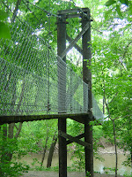
It also features a 140-foot-long swinging foot bridge across the river (pictured right). The bridge will definitely wobble a bit as you're crossing, but not to worry, it's built sturdy. To my knowledge, it's the only bridge of its kind in this area.

As with the river valley spot outside of Mankato, Wildwood is also a good place to cool down in the river if the summer heat is wearing down your biking buzz. If you're able to pack a fishing rod, there's supposedly a few good spots in the park to cast for walleye, catfish and bullheads as well.

Possible ways to expand the loop: If you're in the mood for some ice cream and feel like biking a few more miles, you can keep heading east on County Road 15 out of St. Clair and hang a left onto County Road 3. That will take you into Janesville, where the town's Dairy Queen is located just off the town's Main Street. For all the lake lovers out there, if you head north on County Road 27 out of Eagle Lake, you're only a few short miles of pedaling away from Lake Washington, one of the premier fishing and boating lakes in the area.
 

yaz